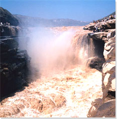
 The physical relief of China drops off in a series of escarpments eastward to the sea, letting in humid air currents from the sea and causing many rivers to flow east. China's rivers amount to 220,000 km in total length. The Yangtze and Huanghe (Yellow) are among the world's mightiest rivers. Other renowned rivers include the Heilongjiang, Songhuajiang, Pearl, Liaohe, Haihe, Huaihe, Lancangjiang, Nujiang, Yarlung Zangbo, and Tarim. The physical relief of China drops off in a series of escarpments eastward to the sea, letting in humid air currents from the sea and causing many rivers to flow east. China's rivers amount to 220,000 km in total length. The Yangtze and Huanghe (Yellow) are among the world's mightiest rivers. Other renowned rivers include the Heilongjiang, Songhuajiang, Pearl, Liaohe, Haihe, Huaihe, Lancangjiang, Nujiang, Yarlung Zangbo, and Tarim.
The many-splendid land of China is glorified by far-reaching mountain chains, magnificent highlands, boundless plains, mountain-rimmed basins, and gentle rolling hille. Mountains and highlands make up 65% of the Chinese continent, which is studded with 2,000 odd natural lakes. The 8,848-metre-high Mount Qomolangma is the highest peak in the world; the lowest part of the Turpan Basin is 154 metres below sea level.
Four major highlands; Qinghai-Tibet Plateau, Inner Mongolia Plateau, Loess Plateau, and Yunnan-Guizhou Plateau.
Four major basins: Tarim, Junggar, Qaidam, and Sichuan.
Three major plains: Northeast China, North China, and the Middle and Lower Yangtze River.
|